Friday 22 February 2019

20th Feb 2019 Vale Luis Neto.

Long, Muddy and Moist. A Tale of the Vale. 

The first interesting aspect of this epic was the composition of the group, with more than the usual chopping and changing, to whit:  Five who were expected did not appear (though four of them had not contacted me), one with a legit excuse, that is a shattered tooth; two unexpected who swore they had given notice (they did, but it went into Spam), and four regulars missing on sad duties. So the party gathered at Tia Bia at the appointed time (at least that went well), was as much a surprise to me as to anyone else.
The final group as follows:

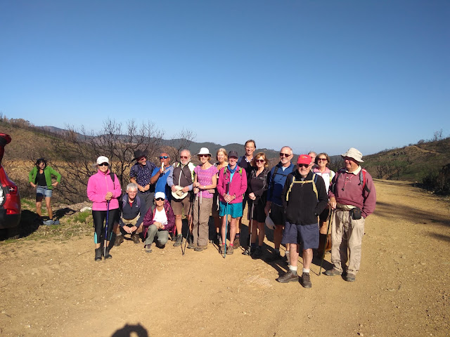
Russell, Sue H, Alan and Trish, Alan and Sandra (welcome back!), Kim and Kirsten (now becoming our regular Danish contingent), John D (even the Tour of Portugal couldn't tempt him away from the AWW), Nicholas, David. Jasper, recovered from his wounds, resumed his herding duties. The weather for the day was perfect for walking, with a cool breeze and hazy sunshine, the sky clearing to full sun as we neared the end. I described this walk as two balloons with a string joining them together, and with one small diversion this is the route we walked.

    Starters minus Leader

Leaving the cafe, we drove down the Cachopo road for three k or so, disembarked and began the walk by descending into the valley on the right - and that's where we got muddy for the first time. Path widening and clearance was happening right along our route, and this section was wet, so the mud was well and truly churned up. The government is now so concerned about fire risk that they are using the army to reinforce the regular workforce, and they are using some serious digging kit. This rather unpleasant underfoot section was relieved by the sight of mimosa in bloom along the valley floor- probably the best display I have ever seen.

After a brief hesitation over the route, and the crossing of a stream swollen somewhat by the recent day of rain, we made our way along the valley and up the steepish hill to Besteirinhos, where the little communal washplace and pump provided an excuse for a rest and a photo. Then onto tarmac for the stroll to and through Montes Novos, where daffodils were glimpsed in a garden. Russell was keen to half-inch a bunch to take home as a welcome back to Linda, but was restrained with difficulty.

    At Fonte da Rata, Besteirinhos. Minus John D behind the camera.

   According to my dictionary, a large rat or a mole. Rato is a mouse.

The track after Montes Novos took us into the moist part of the walk. This wide valley is notoriously boggy after rain, and some time was spent negotiating ponds. After quite a bit of this, I decided to take to the high ground, adding some distance to the walk, but keeping our feet dry. We walked the ridge above the bog and eventually joined the wide track into Vale Luis Neto, where we encountered a large flock of sheep and goats. (lots of ovine livestock today).

Walking through the older part of the village, we saw evidence of re-habitation, together with some rebuilt water fountains. Then it was on to the easier walking terrain across the plateau, and the long descent to Macheira, where we stopped for lunch within earshot of the village dogs, who kept up a welcome throughout.

I had begun to feel quite confident of completing this walk without further problems, but trouble lay ahead. Descending into the valley beyond Macheira, I found the landscape along the stream at the bottom completely changed from my previous visits, and the result was quite a long retrace and a good deal of hesitation and exploration before we found an alternative path to connect with the previous trail. This was tiring and of course added to the distance and time for the day, plus a rather brambly path caused a few scratched legs.

    More livestock as we approached Problem Corner.

Back on my planned route we climbed steeply to Vale da Rosa and continued on the return to Vale Luis Neto. Although the local route signage was better than the last time I walked this way, the paths have been rather neglected, and more scratches were suffered as we approached Corticadas. Turning onto the dirt road back to VLN, we saw cones on the road and beyond them more road works and more camouflage outfits. Then on through the village once more and back to the linking track between the two balloons. 

    Attractive new azulejos at Vale da Rosa

The final stages went to plan, with a very welcome long downward trending ridge to the Barranco-Cachopo road and a return along the valley, where we got muddy for the second time as we joined the outward route. After a final unkind climb back to the cars, we returned to Tia Bia where we were served drinks by a very pleasant and efficient young man, Russell deputising for Sue M as KOTK.

    End of a long day.

Stats (roughly)  23k. 6.75 hours. Moving average around 4.3kph Congrats and thanks to all for patience and assistance. Particular praise to Kirsten on only her second hill-walking adventure for keeping up with the pace and smiling throughout!

Track is in 2 parts


Footnote for those who were there. The path I took which we had to retrace was correct. Where we tried to find a way across the stream was where I crossed previously, but it had become overgrown, as we found out.  A rewrite and reroute will be necessary.

Thursday 14 February 2019

AWW 2019-02-13 We never did see Cansino

For the second week running, the cafe at the meeting point was shut but, bearing in mind the literally life-threatening consequences of this, I took an emergency flask of the caffeinated stuff (Lidl's Gold Instant, there are limits you know). Most people agreed (I think) that it was "better than nothing".

Here are the starters, at the actual start point, all ready to start:

Take 1: (Sarah almost ready)


and Take 2: (Sarah with us ... finally ... <sigh> ...)


I then told them, if memory serves, that the walk would test them to their limits and beyond, they would likely be stung horribly by massed bees, and they would get lost if they didn't listen carefully to my every command (and be found weeks later, lonely, bleached skeletons). I can't remember exactly ...

Despite all this, we set off up a small hill, followed by a looooong downhill. Easy!


Through lots of blackened woodland, past a signpost to Cansino:


Past a couple of buildings, hurriedly abandoned so we could use them as toilets (Homens to the left, Senhoras to the right):
 They can't be much longer, can they?

... and onwards and downwards, reaching the first of our three Lowest Points:


Finally (thank goodness) a nice bit of uphill!

People tried to chainsaw some trees down to prevent us continuing, but they mercifully fell short:


Up to the ridge. (Did I mention that the valley on our left marks the border between the Algarve and the Alentejo?)

... and along ...

Past another signpost to Cansino ...


To the lunch spot (Yes, Sue and Russell got there first, despite my directions):


Did I mention that the valley in front of us marks the border 
between the Algarve and the Alentejo? 

And after precisely 20 minutes we all went downhill again (I'm just saying), to the second of our three Lowest Points, where we teetered elegantly across the stream on some stones I had lobbed in the week before (although Geoff's Crossing was especially elegant, I think):


Easy enough over here!


And then we reached the Final Up; 3km of lovely uphill slog, halfway up marking, for some of us at least, the third of our three Lowest Points:


... and then back to the meeting point, where the cafe was open (Hurrah!)

Dreadlocked Dog (Ewww)


Stats: 
Start Time: 10:20 End Time: 14:33
Distance: 16.34km
Total ascent: 823m (a bit more than I expected, actually :-) )


Many thanks to John D and Geoff for their photos.


Thursday 7 February 2019

AWW 6th February 2019 Fonte Felipe.

What a load of Moaning Minnies

The café was shut. Shame. I told them that it was likely, but they still turned up ages before the planned start and rattled the chains. I am told it was like a scene from the Walking Dead, milling about outside the gates desperate for fresh coffee. Not that I know as I am too scared to watch.

It did not matter, they all arrived at the fonte by the appointed time and John H took the starting photo.

Starting Photo: who is not looking at the camera but still showing their best profile

There are 27 plus 2 dogs in the photo. Including John the photographer.

The leader counted 27 out at the start, and 27 during the walk, and 27 at the end of the day.

However Julie, in the pink, between Isabel and Trish, did not walk with us.

It just shows that as the leader only has about 10 fingers and 10 toes that he has no chance of counting above 20.


It should be noted that Russel was giggling away to himself as he had not taken the bait and was in the body of the group. 


That kept the group together for a few kilometres. Although when they paused for the photograph at these ruins, you can see that we are missing a few: and there is someone else at the back planning to wander around the back of the buildings

And then it was the morning hill. I was straggling at the back. Obviously someone nearer the front had too much energy. They had marked out some "beds" on the track. It had to be a "Scotch" person, as an English person would have marked a hopscotch design.


Those of a certain age and nationality would all have been expert in this competitive sport: I would be surprised if the Portuguese and Danes are familiar.

John H provided me with an early selfie when he wore short breeks. He said that he always used a Kiwi Black polish tin as a peever. Please contact John H for the translations and descriptions. It is all his fault (these funny words), as we slouched at the back talking in the old tongue.


We stopped at the top of the hill and some had a seat.


But we had to get on. so it was round the hills with views over to Rocha de Pena and Foia. That is what you can see from the top of the world.

I had let the front runners "off the leash" and told them to stop at the sign for the step descent, as I had a location planned for lunch. But there was no stopping them and they just shot past it.

Again it was Russel who was in the middle of the group who brought the rest to a halt as planned and when requested strode off to stop the ones at the front.

The rest of us mostly sat at the edge of the track in the cheap "upper balcony" for lunch

 While some took their proper place in the expensive front stalls in the thick of the action.


Then the leader got caught throwing away his banana skin. He was trying to feed the dog roses. But he was seen and someone "clyped" on him to Hazel. The leader just sat there and silently recited his long remembered schoolyard chant "tell tale tit, yer mammy cannae knit, yer daddy cannae go tae bed withoot a dummy tit".

So it was down the hill, through the water along the road and through the water and up the hill.


A typical AWW walk.

There was an offer to shorten the route, but as expected no-one was brave enough to step forward and accept. so it was up the hill and down the valley.


You can see that as we got to the last few kms that the Danes were slowing. Not as much as John and I. However they probably have an excuse as the highest point in Denmark is hardly a hill. John says he is going to lead his next walk nearby


Mollehoj is 170.86m elevation. (I apologise for the lack of the miniscules)

And so all 27 or 26 or ? arrived safely back at the fonte, and it was a short hop (scotch) to the café for a well deserved drink.


The glasses of wine were large and as you can see: after only drinking half of it some were just falling over.

The Statistics / Route


The hills look so much easier in the graph than in reality.

Time and pace: no idea. I just went out for a walk and it was fine.

Frank M 07/02/2019


Sunday 3 February 2019

AWW 30-01-2019 Aguas Frias ( molhadas e úmidas ! )


AWW   30-01-2019   Aguas Frias ( molhadas e úmidas ! )

Picture the scene – it’s 9.50 and only one walker – David -  has found his way to the café in Aguas
Frias for a 10 am start. Had I unknowingly missed out a line in the directions ? or was it the promise
of a soaking ?? or the uncertainty of venturing into The Alentejo ??!! – or worse…nobody wanted
to walk with me !!
Suddenly a rush of cars arrived and the day was saved. 23 people made it to the café and don’t we
look a happy crowd ! I’m overjoyed to have some company after all and everyone else is laughing
at the truck driver who was jokingly threatening  to park his truck between camera and group.


From L to R Kim,Martin,Russell,Geoff,Sarah, David,Frank,Ros,Maria,Hazel,Trish,Sue M,John,
Sue H, Jim,Isabel,Linda,Terry,John H.
Missing from the photo Alan,Ken, John Ha, Scott
Missing altogether as they got lost around Silves – Jan, Pat and Terry.

We set off later than planned and crossed the bridge over a rather sad looking River Arade. A wide
easy track took us in the direction of Zambujal at a cracking pace – most of us needing to warm up
by now. A touch of tarmac led us down through the village and out to the river where I’d planned
a nicely posed group photo on the bridge. See below


We didn’t like to tell him the only bus today had just gone !


Not quite on the bridge and more casual/informal than posed.


From Zambujal we started climbing ( still smiling ) and before too long reached the
boundary of the Algarve and the Alentejo. By this time it was raining and we’d produced
all manner and colour of waterproofs from our rucksacks and were somewhat spread
out – which meant that this important landmark went by unnoticed by most.  


Uphill and still smiling.


Russell was, evidently,  having problems with his new poncho


Until Sue got him sorted out.

The French protester and the man with at least 5 layers of poncho.


On our way down into São Barnabé we came across some livestock,


Slow down – pork crossing.

This fellow was the lucky one as his brother had been made into chouriço here a few weeks
earlier.


Still raining when we reached the riverside café so we gave the picnic area a miss and enjoyed
our canapés under the canopy .


No-one likes a  steep ascent just after lunch but by the time we’d all waterproofed ourselves
again we needed a climb to warm us up.


All the new macs were tried out today – Hazel’s is very floral.


We climbed up high onto a ridge where, normally , we would have spectacular views – today
sadly was more like this,


Before long the track connecting both halves of the figure of 8 was clearly visible
down to our left and, to my surprise, at least half the group ( the “race-ahead of the
leader” half ! ) took this – apparently wanting to go round to S Barnabé again.Or
perhaps they thought it was a short cut back to the coffee and beer ? before I could
even find my whistle Frank had bellowed them back into rank.

Nearing the road back to Aguas Frias some of us took in one more hill and a steep
descent through the hamlet of Aguas Frias de Baixo while the rest walked around the
bottom of the hill to the road.
All arrived back about the same time to enjoy hot chocolate, cold beer, reviving
coffee and relaxing wine.


Was this once the main road to Lisbon ?


Mrs Kitty doing what Mrs Kitties have to do ( and doing it very well ).


Several people asked if we can do this walk again in good weather so let’s plan for Sept.


Many thanks for your cheerful company in spite of the drizzle.


Ed.'s addition :
The above is Ros' verbatim report , she later added a PS with John H's stats from the previous year
Distance:- 21.2 kms
Total ascent:- 809 metres.
I reckoned it was a shade under 5.5 hours including lunch , so probably averaging at just over 4kph, pretty quick, but then we didn't want to hang around and admire the soggy landscape!
Here also are some extra pictures from John  Ospic (Official Starter Photographer In Chief ):


Guess who's wet?