Way out West on the 3rd June 2020. by Jim H
The western section of the AWW (well eight of us) assembled
at the Amigos da Carra’
Cafe at Carrapateria to walk some of the Rota Vicentina.
Left to right: Sarah, Terry, Linda & Russell, Margaret, Scott, Ros.
Sarah & Scott decided not to cuddle.
We set off at a moderate pace in a SW direction. The skies
were blue and it felt warm.
We climbed gradually having nice views of the ocean.
Scott realised that he had forgotten his mask.
After turning inland and crossing the EN268 we walked
through beautiful woodlands.
There were climbs and descents through the woodland.
At a high point we stopped for a banana/water break but
unfortunately Russell got
separated from the others. So I have reattached him. His arm got very long
during
this process.
We descended again into another wooded valley and then I
missed the track out
of the valley. This was not my fault as Sarah was busy talking to me, but
fortunately
we only did an extra 300 metres or so.
We then did a very steep climb and I went from leading at
the front to leading from
the rear. Fortunately nobody knew which way next so everyone waited
for me.
Finally we did the last descent before lunch and the last of
the thick woodland
Scott--surely Sarah is exaggerating??
I went to great lengths to ensure that the walk included all
amenities and the next
stop was the public toilet but no-one availed themselves of this facility
after all the
trouble I went to.
If you zoom in on this photo you will see that even hand-gel
is provided. In these
days of Covid19 hand washing is essential.
It was now just 2 kilometres on a nice wide flat track to
Pedralva where we stopped
for lunch.
We eat our own food at a very comfortable and shaded picnic
area
We then set off to walk back to Carrapateira via Vilarinha.
It was a flat walk through
a beautiful green valley with many colours from various flowers.
Normally there is the excitement of getting across 6 river
crossings but all
crossings were totally dry and so the walk was without incident.
Sarah’s photo of some donkeys we passed
Two more of Sarah’s photos
At Vilarinha there was a short stretch of tarmac before we
turned onto the last
section of track which took us through Beicudo.
This is a shaded tree lined track and indeed goes all the
way back on the flat into Carrapateira.
However I think it always best to finish a walk with a
descent so that means a climb
was needed, (to then do the descent!). We then turned onto a track to take us to the
start of a
climb taking us up to the top of the hills, behind the town, where the
trig-point is situated. This climb was steady away and as a good leader I went to the
back to make sure no-one got lost!
As I was the last to arrive at the trig-point I apparently
had
missed a photo opportunity, when everyone had climbed up.
Well that's what they told me!
Finally then the last km was downhill all the way to the
cafe.
And a final bonus was that the drinks bill was very
reasonable.
STATS:
Distance: (with extra spur) 19.18km
Active Time: 5hr 14min Speed 3.67km/hour Total Ascent 448m
MAP TERRAIN
 Left to right: Sarah, Terry, Linda & Russell, Margaret, Scott, Ros.Sarah & Scott decided not to cuddle.We set off at a moderate pace in a SW direction. The skies were blue and it felt warm.We climbed gradually having nice views of the ocean.
 Scott realised that he had forgotten his mask.After turning inland and crossing the EN268 we walked through beautiful woodlands.There were climbs and descents through the woodland.At a high point we stopped for a banana/water break but unfortunately Russell gotseparated from the others. So I have reattached him. His arm got very long duringthis process.
 We descended again into another wooded valley and then I missed the track outof the valley. This was not my fault as Sarah was busy talking to me, but fortunatelywe only did an extra 300 metres or so.We then did a very steep climb and I went from leading at the front to leading fromthe rear. Fortunately nobody knew which way next so everyone waited for me.Finally we did the last descent before lunch and the last of the thick woodland
 Scott--surely Sarah is exaggerating??I went to great lengths to ensure that the walk included all amenities and the nextstop was the public toilet but no-one availed themselves of this facility after all thetrouble I went to.
 If you zoom in on this photo you will see that even hand-gel is provided. In thesedays of Covid19 hand washing is essential.It was now just 2 kilometres on a nice wide flat track to Pedralva where we stoppedfor lunch.
 We eat our own food at a very comfortable and shaded picnic areaWe then set off to walk back to Carrapateira via Vilarinha. It was a flat walk througha beautiful green valley with many colours from various flowers.Normally there is the excitement of getting across 6 river crossings but allcrossings were totally dry and so the walk was without incident.
 Sarah’s photo of some donkeys we passed
 Two more of Sarah’s photosAt Vilarinha there was a short stretch of tarmac before we turned onto the lastsection of track which took us through Beicudo.
 This is a shaded tree lined track and indeed goes all the way back on the flat into Carrapateira.However I think it always best to finish a walk with a descent so that means a climbwas needed, (to then do the descent!). We then turned onto a track to take us to thestart of a climb taking us up to the top of the hills, behind the town, where thetrig-point is situated. This climb was steady away and as a good leader I went to theback to make sure no-one got lost!
 As I was the last to arrive at the trig-point I apparently hadmissed a photo opportunity, when everyone had climbed up.Well that's what they told me!Finally then the last km was downhill all the way to the cafe.
 And a final bonus was that the drinks bill was very reasonable.STATS:Distance: (with extra spur) 19.18kmActive Time: 5hr 14min Speed 3.67km/hour Total Ascent 448m
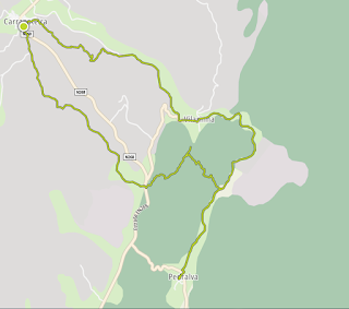


Excellent walk Jim....You'll need to repeat it when we are out there please.
ReplyDeleteSome very good things have been spoken about this walk; well done! Sorry that I had to miss it... Next time!
ReplyDeleteObviously a great walk, Jim, I remember the previous one. I´d do it again in cooler weather.
ReplyDeleteThanks Jim we really enjoyed the walk and the pace was good too.
ReplyDelete