Friday 30 April 2021

A hike to "The Crack" (Northern Ontario, Canada)

With wall-to-wall sunshine & a temperature forecasted to reach a high of 8C, we decided to do a hike to "The Crack", which we hadn't done for several years. As our Province remains in Covid lockdown, it was a hike we had to do alone. A 20 km car ride west along the TransCanada Hwy brought us to the Little Pic River Bridge and the starting point of our days adventure. We would rate this hike a 4 - 4.5/5, because of the steep rocky climbs & descends. The first part of the trail is a steady climb to reach the top of "The Crack", followed by a steep rocky climb down a ravine to reach the bottom of "The Crack" and its entrance. 

The phrase of the day was "watch your footing". 

No mosquitos, yet!


It's 10:30 am (4C) and Trudy is eager to start


We arrive at a small lake


The trail brings us to the end of this lake, which normally flows into a small stream but busy beavers have built a dam to stop the normal flow of water.


Appears the beavers need to make repairs as some water is escaping into the stream.


Still evidence of Winter!


 Trudy blows a tire and needs to make repairs of her own!

A view of the Canadian Pacific Railway tracks and bridge, which spans across the Little Pic River. 


A helpful hiker has left behind a rope to assist with descending this rock face.


A beautiful photo of Trudy and a small cave behind her. Glad a bear wasn't inside sleeping!


We reach the top of "The Crack. The green rope will be needed to climb out. 


A disappointing look down into "The Crack" reveals snow & ice with the rope embedded in the ice. We've decided to continue with our plans of entering "The Crack" from the bottom entrance but we will not be able to exit from the top. 


A view of Lake Superior & the mouth of the Little Pic River from the top of "The Crack"


Hard to tell from the photo, but we need to make our way down this steep ravine to reach the opening of "The Crack"


A short break!


You can barely see Trudy as she begins her descent.


Watch your footing!


Halfway down!

Finally make it to the bottom and onto the tracks. Just a short walk along the tracks to reach the entrance.


Opening to the Crack! A tight squeeze in... Because of the snow & ice inside, Trudy decided not to enter. The following photos are views inside "The Crack". One of the photos includes my hat to show how narrow the passage is.


Because of the snow & Ice, I couldn't go any further. In another month, it should all be melted. Unfortunately, "The Crack" never completely dries out, with constant water dripping down the sides.

We had no choice but to climb back up the ravine and onto the trail back to our car.


1. "The Crack" /  2. Starting Point / 3. Ravine / 4. CPR tracks / 5. Little Pic River

Lenght:  8 km
Time:  3 1/2 hrs  


  Nag, Nag on the Craggy hill of Tor 

Due to our proposed leader having a knee injury, I stepped in to lead one of my regular routes on the Craggy hills of Funchais and Tor. Having messaged several others, to join us in the new bubble of 6,  I had no takers. One was down with food poisoning, another, puppy sitting, and three out at work. So, poor, Alan had to put up with a clacker of females; chit chats for 18 kms crossing.  May well be 23kms. Do you want to leave now Alan???

We met at the Cafe Mai 1st  located in the small hamlet of Funchais (Tor Freguesia) at 10.00. We were promised a mixture of cloud, sun and rain.


 From left to right:   Sue, Alan, the leader, Jan and Brenda with Mamas, our four-legged furry friend from Cyprus. (His name derived from a Christian Saint from Anatolia ) 

We began our walk traipsing through the hamlet of Funchais following the lane of Beco das Nespereiras. Where we found a most delightful ‘village’, without the manager and pilgrims as we saw on an earlier walk around Easter time.  Still an interesting piece of handy work. 


         We made our way through Travessa do Alecrim where we started the first climb out of the hamlet, passing             some individual dwellings. We then left civilisation and continued our craggy, rocky hill climb toward the           summit (whence the name Tôr is derived), whilst keeping parallel with the Ribeira de Algibre-Tôr road. In the distance on  the opposite hill, the small hamlets of Boa Hora and Parragil were clearly visible. 


However, this was an adventure (not sure if there was much belief in the leader at this stage) as we didn’t go to the summit, as originally planned instead we followed this path heading West which led us onto the Benafim/Ribeira de Algibre road. Heading towards the dark heavens!!!


Which Direction?  

Raised heads of Poppies in their glory swaying gently in the breeze.

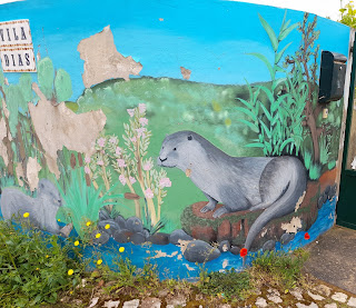
Heading towards the Bridge at Ribeira de Algibre we took in the local art work and handicraft.

 Oops, a couple of Otter’s frolicking on a wall???


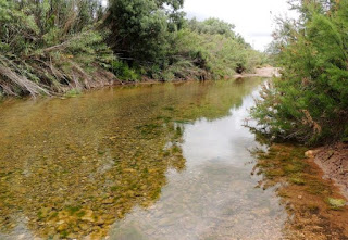
 As we crossed the river we took a view of the depth and the possibility of crossing a little further on. 


Ribeira de Algibre

We were now following the river, passing by more vineyards which then led us uphill in the direction of Soalheira. A little further up we found a small wall in the sun which afforded seats to stop for lunch.


Shortly after sunny lunch stop, we continued up and then eastward and finally heading down towards the river. The rain started and we kitted up for the wet weather, yet again!!


As we tramped along we came about some interesting natural stone sculptures..... 


Any suggestions from our readers of what they could be? We had plenty of skewed ideas!

Eventually, we came to our turning point which led us down to a river crossing and Sue decided to have a look at the depth and whether it was navigable?


Not this section, too deep!! Alan, suggested he could swim across but he had forgotten his trunks. We promised to avert our eyes!!! 

My original plan was to go further up the river, as there was an opportunity of a diagonal crossing where we thought that the water would be shallower. So, off we went to the other crossing point and on arrival we put our thinking caps on, whilst reviewing the varied depths at entry points and where we could cross. We decided, in the end, to go straight up the middle keeping to the small pebbles. No change of footwear for these adventures, straight in and Alan has now christened his new walking boots!!! However, as we got nearer the middle the water got deeper and deeper followed by more female screeching! Alan, at this point decide to take some amusing photographs!!! 


We crossed safely and finally we squelched our way to the cafe in Funchais for some refreshments.


Drying out.


Time:        A tad over 5 hours. Including the lunch stop of 15 minutes.

Length:    17.5 kms

Route:      A slight change to the original one.


Thank you to the adventurers and the photographers. Having 50% of our walkers from Yorkshire today, reminded me of Wallace and Gromit - A Grand Day Out! Could it be the Chicken Run, next time???  

Thursday 29 April 2021

Fonte da Benemola: Between a Rock and a Hard Place: 28th April 2021

 The Syncopating Six met in the lay-by, just past the cafe Sol e Sera at Corte Garcia north of Loule.

The cafe was closed and the leader would have taken a lot of stick about that, except that Ken is never sure where his stick is.

Instead he took the starting photo and Miriam kept control of the stick

Ken, David, Miriam (with Ken's stick) Jasper, Bica, Sergio and Frank M

The sun was shining as we set off upwards to the summit of Cepo (427m). We were all six in step at the start -we were the syncopating six - but as we got higher we became more ragged.

and as we passed some bee hives these two broke ranks and ran past he rest of us

and like the grand Old Duke of York whose men march to quicktime, when we were only half way up, we stopped for a drink and rest

The skies were still mostly blue but the clouds were stacking up. But what did we care.  We marched all the way to the summit.

and as we all looked east except from the camera man, we did not see the clouds rolling in.

A dyslexic ex pupil of Ros had been to the top of Cepo before her.

So with the first hour gone and the Rock conquered, we set off downhill towards the west and Fonte da Benemola and towards the darkening skies.

The rain has come. But it is not too bad.


Ken got suited up. But he forgot to put his back pack on. and where is his stick? 


where he left it.
heads down and lean into the rain.

But the rain quickly passed. This year has been great due to the rain. The colours are just fine.

Flowers

more flowers and i do not know what they are called

Red flowers

So we reached the font and the water was streaming down in torrents, but not out of the sky. The water in the font was more than we have seen for several years. The rain had gone for the moment. It actually had not been too bad. The colourfull rainwear had probably scared it away. 

And we had a proper seat

The font is at the bottom. It is is where the water tends to go. So we set off for the "hard place" which is Querenca on the hill.

And we just got there on time. We decided that the "prior to the end of the walk" drinks would be had in the square in Querenca.

No sooner had we sat down than the heavens opened.


Some were hoping that the rain would stay for an hour or so, and we could have a few more drinks, but no, after about 20 mins it stopped. And so the syncopating six were off, We marched down the hill, with Ken beating a rhythm with his retained stick, yomped across the fields and back to the start.

Statistics

Distance     17.0km (slightly longer than planned as Frank got lost)
Elevation     427m
Time            5 1/2 hrs but included time for lunch, and drinks at the cafe in Querenca
Pace             Fine
Weather        Great 


Frank M
29th April 2021